Sunday, November 17, 2013
PLSS
http://homepages.ius.edu/PGALVIN/g333/How%20to%20Read%20Topographical%20Maps.htm
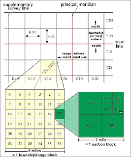
This is a example of a PLSS map. It is a type of land survey that we learned about the early on in the semester. PLSS is a portioning system that covers much of the United States. One thing that is different about this form of partitioning is that relies more on description and less on accuracy. It allows us to have a quick approximation of a location. The system starts with a large block made up of townships, we cab then enter a one mile block within those townships to see how the land is divided in those places.
Subscribe to:
Post Comments (Atom)

No comments:
Post a Comment